Welcome To Map Pilot From Maps Made Easy Beginners Course
This course is geared to drone pilots who are just starting to learn about autonomous drone flight. As noted in the title, this is a beginners course. We'll be talking about Maps Made Easy's "Map Pilot" flight app. Students should be aware, this particular flight application only works on iOS devices. It does not work with Android devices.
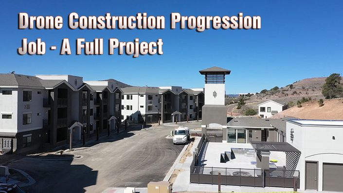
In this class we'll learn how to setup flights for 2 dimensional models & 3 dimensional models that can be used over and over again. Students will also learn that creating complex automated flights can take some time to prepare. However, the time invested is worthwhile if you're interested in creating re-usable flights for for modeling. Map Pilot works well for applications like Drone Construction Progression Reporting.
Map Pilot For Beginners Curriculum
- Map Pilot Tutorial 1 - Introducing Map Pilot (15:39)
- Map Pilot Tutorial 2 - Map Pilot Settings (15:10)
- Map Pilot Tutorial 3 - Setting Up A Plan (23:49)
- Map Pilot Tutorial 4 - Connected Drone Camera (13:49)
- Map Pilot Tutorial 5 - More Menu Options (16:36)
- Map Pilot Tutorial 6 - Simulate a flight mission (14:08)
- Map Pilot Tutorial 7 - Flying The Dells For 3D Model (11:07)
- Map Pilot Tutorial 8 - Processing your Map Pilot Data (11:46)
- Introducing Map Pilot Pro - Things are changing (11:18)
- Lecture 1 _ The New Map Pilot Pro Interface (14:20)
- Lecture 2_ The Map Pilot Pro Flight Screen (13:34)
- Lecture 3_ Map Pilot Pro Flight Setup (15:14)
- Lecture 4_ Map Pilot Pro With Drone Connected (13:29)
- Lecture 5 _Map Pilot Pro With Drone Connected Part 2 (11:00)
- Lecture 6_An Actual Flight With Map Pilot Pro (14:54)
- Lecture 7_Upload To Maps Made Easy From Your Smart Device In The Field (6:08)
- Lecture 8_Uploading To MME Via Web (12:04)
- Lecture 9_Building A Second Model With Map Pilot (19:51)
What You'll Learn
•Flight setup in Map Pilot
•Creating flight missions for 2D & 3D Modeling with drones
•Map Pilot's Interface
•Autonomous Drone Flight
•Data collection for developing models in other applications
Is This Class For You?
If you're a seasoned drone operator who has already been using other capture applications for 2D & 3D Modeling this class might be a little basic for you. If you're a new drone operator interested in doing 2D & 3D modeling with an app that can help you plan efficient and re-usable flight paths for applications like Agriculture, Construction, Property Monitoring, & other applications, this might be a great starter class for you!

Featured Classes
Below you'll find a list of courses that are related to this class. Litchi & Ground Station Pro are featured as flight capture apps for your business. And the Progression Job class utilizes Map Pilot as a featured app as well.